

Description
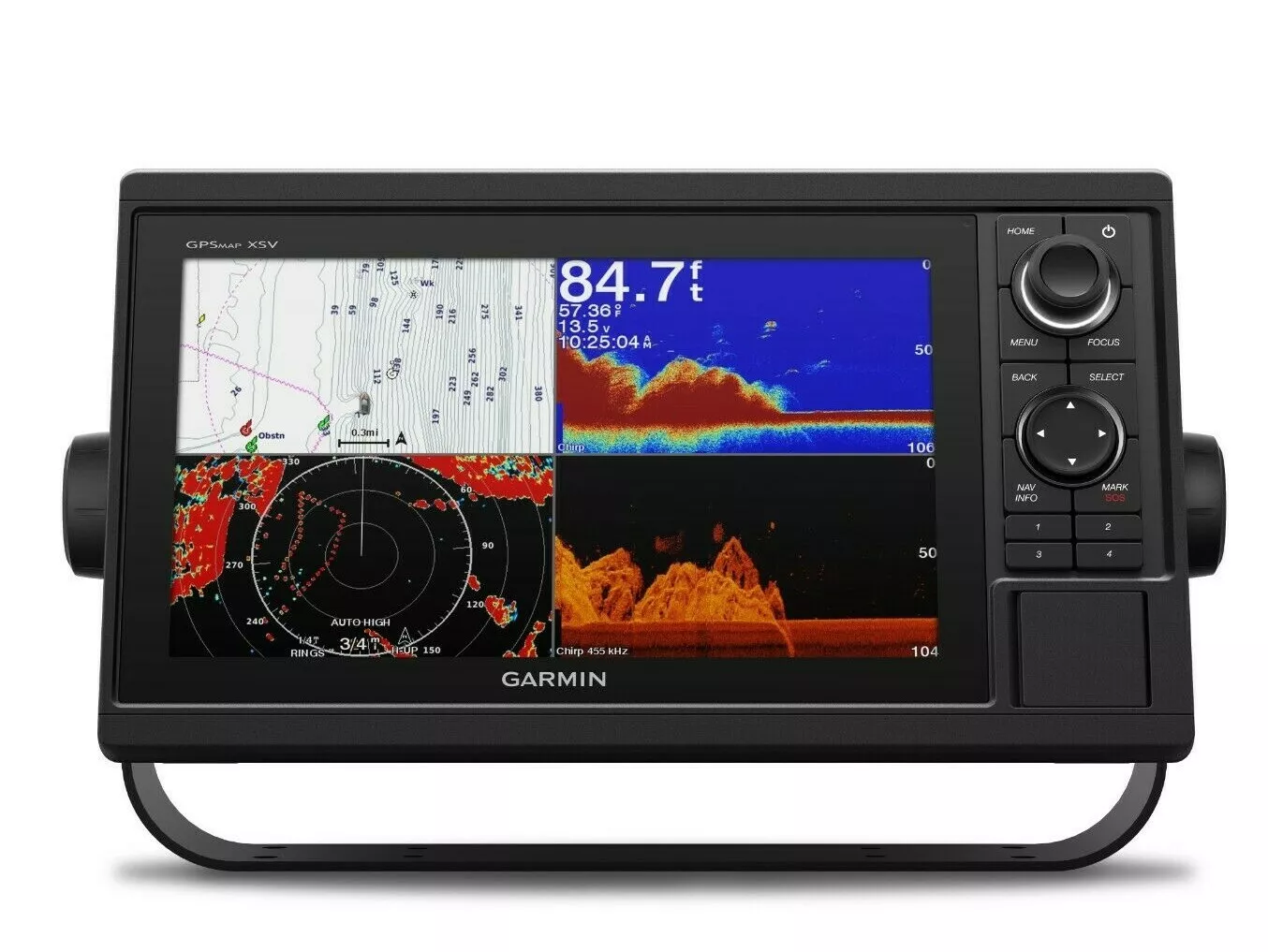
Garmin 010-01740-03 GPSMAP 1042xsv without Transducer 10″ Marine Chart Plotter
Charts and Maps:
BlueChart® g3: Detailed charts for coastal waters.
LakeVü™ g3: Detailed mapping for lakes in the U.S.
Sonar Type: ULTRA HIGH DEFINITION
Traditional CHIRP: Good for displaying fish arches.
ClearVü: Excellent for displaying fish and structure below your boat.
SideVü: Excellent for displaying fish and structure to the sides of your boat.
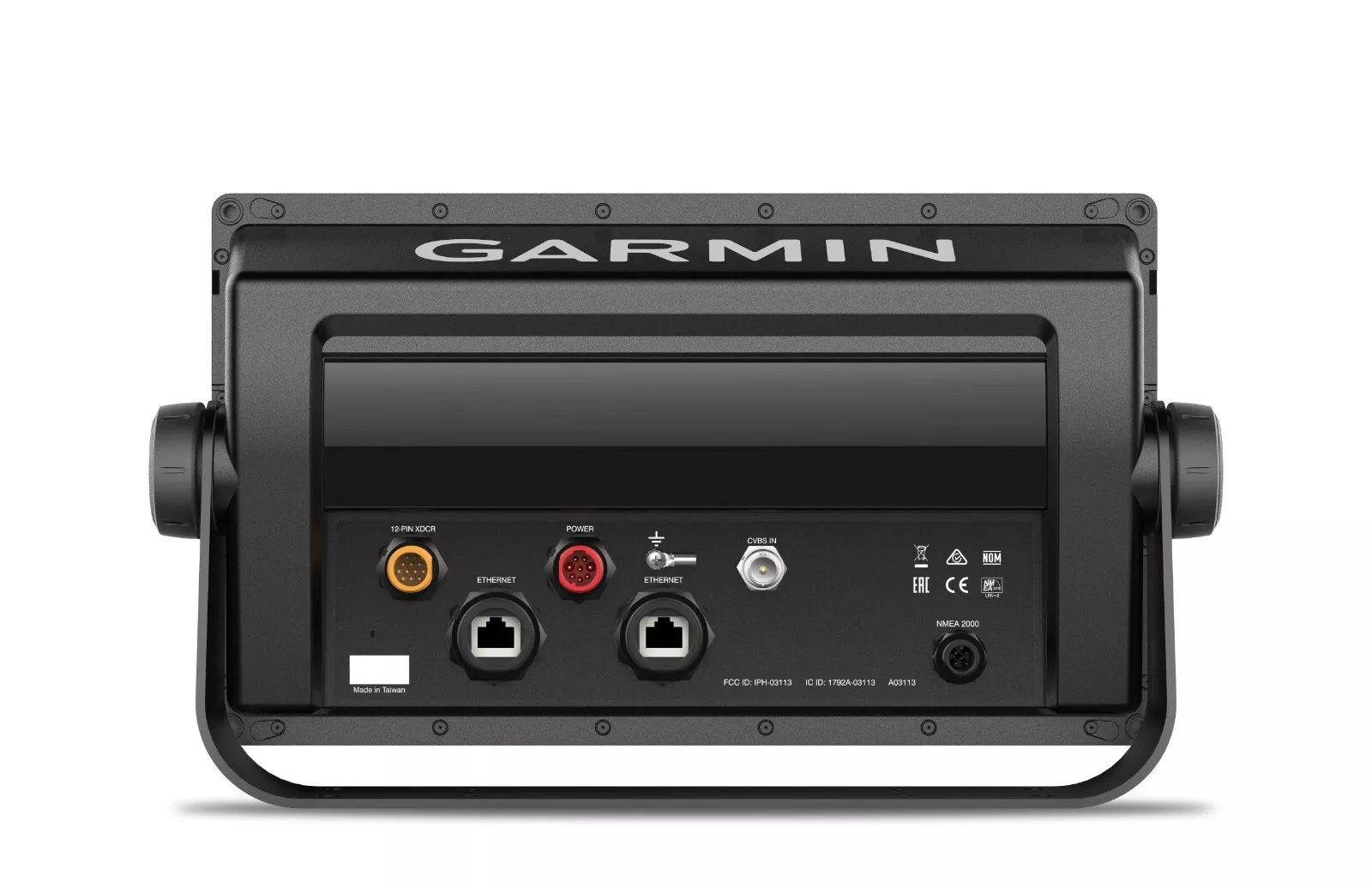
Garmin 1042xsv Chartplotter/FishfinderWith 10″ LCD, LakeVu and BlueChart Offshore Maps, and Built-in FishfinderExperience an advanced all-in-1 solution with our 10-inch GPSMAP 1022xsv keyed combo. comes with or without a transducer for Garmin CHIRP sonar, CHIRP ClearVü and CHIRP SideVü. It also has built-in support for Panoptix all-seeing sonar and premium Garmin sonar modules (transducers sold separately). Features a large, bright screen coupled with a quick and easy-to-use keypad interface with user-programmable keys and a multifunction control knob.Right out of the box, you have access to some amazing sonar capabilities; all you have to add are transducers. Comes with built-in Garmin 1 kW CHIRP sonar, CHIRP ClearVü and CHIRP SideVü scanning sonar. It even supports Panoptix all-seeing sonar, premium Garmin sonar modules and a wide range of transducers (sold separately). Networked combos can share their internal sonar with any other device on the network. You can also choose what information is overlaid on the sonar screen; for example, radar, time of day or GPS speed.Garmin Marine Network support allows sharing of sonar, maps, user data, dome or open-array radar, IP cameras and Panoptix™ sonar among multiple units. Includes NMEA 2000 network connectivity and NMEA 0183 support for autopilots, digital switching, weather, FUSION-Link, VHF, AIS and other sensors.You also enjoy built-in Wi-Fi and ANT wireless connectivity directly to quatix® marine watches, Garmin Nautix™ in-view display, gWind™ Wireless 2 transducer, GNX™ Wind marine instrument and wireless remote controls. You can even stream and control a VIRB action camera from the chartplotter.Fast, responsive built-in 10 Hz GPS and GLONASS receiver refreshes your position and heading 10 times each second to make your movement on the screen more fluid. It makes dropping up to 5,000 accurate waypoints – and finding your way back to them – quick and easy.
Antenna: Internal or external over NMEA 2000
Dimensions: 12.5”W x 7.3”H x 2.7”D; Wt: 4.1 lb.
Display: 10” diag. color LCD, non-touch
Interface: NMEA 0183, NMEA 2000, Video in, WiFi, Garmin Marine Network (Ethernet)
Mapping: Preloaded BlueChart g3 (coastal maps) & Lake; HD (inl& maps)
Other Functions: Optional XM satellite weather and audio; AIS support (receiver required); fuel & engine monitor
Radar: Wide variety of radar antennas available
Resolution: 1024 x 600 pixels
Sounder: Built-in traditional (50/77/83/200 kHz), CHIRP (low, medium, high), CHIRP ClearV
Waypoints/Routes: 5,000 waypoints, 100 routes, 50,000 trackpoints, 50 tracks


Reviews
There are no reviews yet.